
The UN General Assembly has taken a significant step by voting to replace the traditional world map with one that more accurately represents the size of Africa.
The “Correct the Map” resolution, championed by Togo and supported by members of the African Union (AU), garnered backing from 164 nations, including France and the UK. Notably, the United States was the only country to oppose the resolution, with six nations choosing to abstain.
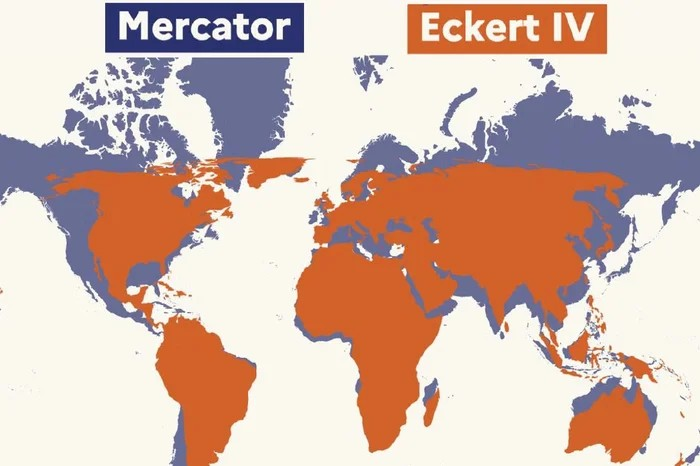
Critics have long challenged the Mercator map, which has been widely used since the 16th century, for its misleading portrayal of Africa’s size, depicting it as comparable to Greenland despite Africa being 14 times larger. This misrepresentation can undermine the development needs and potential of countries situated near the equator.
Originally designed in 1569 by Flemish cartographer Gerardus Mercator, the map aimed to assist European explorers in navigation. However, the distortion arises from the inherent challenge of accurately depicting a three-dimensional globe on a two-dimensional surface. Every world map inevitably involves compromises.
The Mercator projection diminishes the size of countries near the equator while exaggerating those closer to the poles. To address these inaccuracies, a dedicated team of cartographers developed the Equal Earth projection in 2018, an equal-area map that the AU’s 54 member states adopted in February, asserting it “more accurately represents the sizes of all continents, particularly Africa.”
Prior to the vote, Togolese Foreign Minister Robert Dussey articulated the importance of this change, stating to Reuters, “A fair world begins with a fair map.” During a UN briefing, he emphasized, “A map is never neutral. It shapes perceptions and influences our understanding of the place of peoples and continents in the world.”
While the UN vote is non-binding, it will prompt a shift in the maps utilized by institutions globally, fostering a more accurate representation of our world.